

FACULTY OF FORESTRY AND ENVIRONMENT

FONT SIZE


BACKGROUND COLOR
SCREEN READER
-
Perisian untuk membantu pengguna kurang upaya untuk menterjemah teks kepada ucapan suara / audio:
https://ttsreader.com/ https://www.naturalreaders.com/online/


DOCUMENT

» ARTICLE » Coastal Hazards, Vulnerabilities and Adaptation Strategies in Malaysia
Coastal Hazards, Vulnerabilities and Adaptation Strategies in Malaysia
Global sea levels are rising and accelerating due to the climate change. In Malaysia, studies show that the average rise in sea level has increased by more than 0.1 meters since 1993 and it is predicted that the rate will accelerate and reach up to 1 meter in the year 2100.
Worryingly, this continuous increase will have the present and immediate effect in rising the frequency and magnitude of extreme sea levels. Extreme sea levels that comprised of storm surges, high astronomical tides, and waves will become more frequent and intense in the future. This will contribute to the coastal flooding and erosion especially in the coastal low-lying areas in Malaysia.
In particular, the co-occurrence of these extreme events with the Northeast Monsoon and/or climate modes of La Nina will exponentially increase the risk of flooding. The higher amount and longer duration of rainfall together with the monsoon surge during this period contributed to the flooding that occurred almost every year along the east coast Peninsular Malaysia. According to the National Coastal Erosion Study (2015), about 1348 km of shoreline in Malaysia has been eroded. The critical and significant coastal erosion areas are mainly located in Sarawak, Sabah, Johor, Perak and Terengganu. In particular, the critical erosion areas with an aggregate length of 55.4 km are rapidly retreating at a pace of more than 4 m/year. Under the Second National Coastal Zone Physical Plan (RFZPPN2), the National Coastal Vulnerability Index (NCVI) has been introduced to assess the level of coastal vulnerability in Peninsular Malaysia and the Federal Territory of Labuan. NCVI is a combination of Physical Coastal Vulnerability Index (CVIP), Biodiversity (CVIB) and Socio-Economic (CVIS).
The NCVI map shows 72 out of 175 unit areas (41%) are at very high and high level of vulnerability (Fig. 1). The area that recorded the highest NCVI were in the state of Selangor, namely Klang (B09), Kapar (B08), Ujong Permatang, Kuala Selangor (B05) and Api-Api (B06). The main factors that have contributed to the significant increase in the NCVI level includes erosion, geomorphology, sea level rise, tsunami threat, population density, the existence of important infrastructure and public facilities, and the existence and gazetting of important areas marine ecosystems.
Furthermore, the main physical threat (CVIP) to coastal areas is concentrated on the West Coast of Peninsular Malaysia. Among the most affected states are Selangor, Perak, Penang and Kedah. The main factor contributing to the high CVIP values for these states is the sloping, muddy and exposed topography in most areas (without forest cover).
Reducing the impact of sea level rise and associated coastal hazards require timely and adequate commitment to coastal adaptation. First and foremost, in line with the climate action strategy under the United Nations Sustainable Development Goals (SDGs), government initiatives and investments in climate resilience and adaptation must be an ongoing priority.
Recently, consideration of Selangor State government to declare a climate emergency is very relevant and must be supported as this state is among the most vulnerable to coastal hazard in Malaysia. Declaring climate emergency implies that climate change must be addressed immediately through coordinated efforts by authorities and citizens to mitigate and reduce its effect in order to protect people and environment.
Secondly, the coastal communities in the vulnerable areas must be engaged in long-term planning efforts. The residents need to be well-informed in addressing the risk and challenges and to be more prepared and cooperative in reaching effective, equitable and locally appropriate long-term solutions. In responding to sea level rise, adaptation strategies includes (i) physical protection such as building a seawall, (ii) advance by coastal reclamation project that should be able to greatly support natural accretion of land, (iii) accommodation of the risk such as raising building; and (iv) retreat by moving coastal community and assets out from the vulnerable areas.
Continuous monitoring of coastal hazards and vulnerabilities will provide vital information to relevant authorities in making well-informed decision regarding coastal adaptation strategies. The selection of the adaptation strategies must be made with the goal of reducing risks, exposure, and vulnerability utilising an integrated strategy that also takes into account conflict resolution practices and public participation. This will enable better execution of adaptation strategy and conflict avoidance in the future.
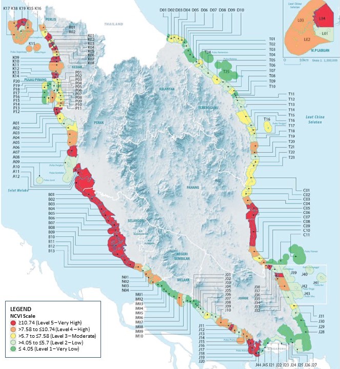
Fig. 1. National Coastal Vulnerability Index (NCVI).
Date of Input: 07/02/2023 | Updated: 11/07/2023 | masridien
MEDIA SHARING
SEE ALSO


FACULTY OF FORESTRY AND ENVIRONMENT
Universiti Putra Malaysia
43400 UPM Serdang
Selangor Darul Ehsan
43400 UPM Serdang
Selangor Darul Ehsan
+60397697171
+60397693768
FACULTY OF FORESTRY AND ENVIRONMENT
Universiti Putra Malaysia
43400 UPM Serdang
Malaysia
+60397697171
+60397693768
dean.forenv@upm.edu.my
EMERGENCY LINE (24 HOURS)
AUXILIARY POLICE
& SECURITY CENTER
AUXILIARY POLICE
& SECURITY CENTER
03-9769 4999 | 03-9769 1399
03-9769 1999
03-9769 1999


© 2026 FACULTY OF FORESTRY AND ENVIRONMENT


X, (11:01:29am-11:06:29am, 03 Aug 2026) [*LIVETIMESTAMP*]